


⭐⭐⭐⭐⭐ 5.0 Google Rating | Tripadvisor Travelers’ Choice


SMALL-GROUP CRATER HIKE IN HAWAIʻI VOLCANOES NATIONAL PARK
4.5-Hour Kīlauea Iki Crater Hike
This 4.5-hour Kīlauea Iki hike takes a public small group approximately 4.5 miles through one of Hawaiʻi Volcanoes National Park’s most memorable landscapes. Descend beneath ʻōhiʻa lehua and hāpuʻu ferns in the native rainforest, then step onto the crater floor and cross the solidified lava lake created during the 1959 eruption.
Along the way, your interpretive hiking guide explains how the eruption reshaped Kīlauea, what the volcanic features reveal and how plant life is returning around the crater. Designed for guests comfortable with moderate hiking, this guided crater-floor crossing combines forest, geology and volcanic history. The exact route may change with trail access, weather, volcanic activity and current park conditions.
⭐⭐⭐⭐⭐
Tripadvisor Travelers’ Choice
Recognized traveler trust

125+ Happy Hikers
Guest experiences

20+ Years of Combined Guiding Experience
Professional experience

Authorized Commercial Hiking Operator
Commercial Use Authorization
4.5 Hours
Group Size
2–10 Guests
Distance
Approx. 7 km / 4.5 Miles
Difficulty
Moderate
Elevation Gain
Approx. 300 m (985 ft) ascent / 338 m (1,110 ft) descent

Ages
7+
Price
$157.07 per Person, Tax Included
Tour type
Public Small Group
8:00 a.m. or 10:00 a.m.
Why Choose This Kīlauea Iki Hike?

Cross a Solidified Lava Lake
Leave the crater rim behind and walk across the hardened lava lake created during the 1959 Kīlauea Iki eruption.

Discover What the Landscape Reveals
See fissures, crater walls, hardened lava and the former eruption vent while your guide explains what these features reveal about the events of 1959.

From Native Rainforest to Crater Floor
Descend through shaded native forest before stepping onto the open volcanic terrain below. The dramatic change in landscape is part of what makes this route so memorable.

A Small Group With Room for Questions
Public hikes are limited to 10 guests. When more than eight guests come from unrelated parties, a second guide joins the group to provide more individual attention.
What Happens Along the Kīlauea Iki Trail?
The usual experience follows Kīlauea’s crater rim, descends through native rainforest to the solidified lava lake, crosses the crater floor and then climbs back out. This part of the Kīlauea Iki hike allows you to experience the crater as one connected landscape, with each stage revealing a different view of its scale, terrain and surrounding forest.
01
See Kīlauea Iki From the Crater Rim
From above, you can see the broad crater floor and the steep forested walls surrounding it. The view helps you understand how far the trail descends and how different the exposed volcanic terrain is from the rainforest growing along the rim.
The Crater Rim Trail connects with the wider trail system around Kīlauea, while the Kīlauea Iki Overlook is a familiar reference point in the surrounding area. Your guide uses the view from the rim to introduce the landscape before the group begins moving toward the crater floor.


02
Descend Through Native Rainforest
As the trail leaves the crater rim, the surroundings become cooler, greener and more sheltered. The forested descent may include switchbacks, stone steps and changes in footing as the path passes beneath hāpuʻu tree ferns, ʻōhiʻa lehua and other native vegetation.
Changes in shade, temperature and ground conditions become noticeable as you move lower. The dense forest then begins to open, revealing the darker volcanic surface of the crater floor ahead.
03
Cross the Solidified Lava Lake
The rainforest gives way to the open crater floor, where you walk across hardened lava left by the 1959 eruption. The surface can be rough and uneven, with cracks, ridges and changing volcanic textures visible along the established route.
The former eruption vent lies below Puʻupuaʻi, the cinder cone formed during the eruption. National Park Service-placed ahu, or stone cairns, help identify the route across the exposed terrain. Guests should follow the guide and leave these markers undisturbed.
There is little shelter on the crater floor, so conditions can feel warmer, wetter or windier than they did in the forest. The open setting also gives the group time to observe the landscape, take photographs and ask questions as different features appear along the way.


04
Climb Back Through the Forest
After crossing the solidified lava lake, the trail begins a sustained climb from the crater floor. The return passes back into the forest, where shade and vegetation gradually replace the open volcanic landscape. Your guide manages the group’s pace and includes appropriate pauses during the climb.
Geographic Context: Kīlauea Iki and the Summit
Kīlauea Iki is a pit crater formed through collapse. It is separate from Kīlauea’s larger summit caldera and should not be described as the summit caldera itself.
Halemaʻumaʻu Crater lies within the broader Kīlauea summit caldera. Volcano House and Crater Rim Drive are useful nearby reference points for understanding the area, but they are not guaranteed stops on this tour.
The route and direction may change with trail access, closures, weather, volcanic conditions and the group’s ability.
Walk Across the Lava Lake Formed in 1959
The geology visible along the Kīlauea Iki crater trail records five extraordinary weeks in 1959, when rising magma, repeated lava fountains and a growing lava lake transformed the crater.
Understanding that sequence makes the vent, fractures, terraces, colored rocks and rising steam on the crater floor much easier to interpret.
How the Eruption Began?

The first signs appeared months before lava reached the surface. In August 1959, the Hawaiian Volcano Observatory began recording deep earthquakes beneath Kīlauea.
By October, measurements showed that the volcano’s summit was inflating as magma entered and pressurized the underground reservoir. The number and intensity of earthquakes continued to rise as the magma moved closer to the surface.
On the night of November 14, 1959, a half-mile fissure opened along the wall of Kīlauea Iki. A curtain of lava initially erupted from several vents along the fissure. Within a day, those openings had consolidated into one primary eruption vent.
The eruption did not continue at a steady rate. Over the following five weeks, lava emerged in 17 separate episodes. Each episode added more molten rock to the crater and changed the shape of the growing lava lake.
A 1,900-Foot Lava Fountain and a New Cinder Cone
The most powerful episode sent lava approximately 1,900 feet above the vent, setting a record for the highest lava fountain measured in Hawaiʻi.
The fountains repeatedly carried molten rock and smaller volcanic fragments into the air before they fell around the vent and onto the surrounding crater rim.
This ejected material is broadly known as tephra, but it can take several forms:
-
Cinder consists of frothy fragments that cool in the air.
-
Spatter remains hot and soft enough to flatten or fuse after landing.
-
Pumice is highly gas-rich volcanic rock.
-
Reticulite is an especially delicate, sponge-like form created by expanding gas bubbles within the lava.
As cinder and spatter accumulated, they formed Puʻupuaʻi, the cone beside the eruption vent. Its Hawaiian name means “gushing hill,” reflecting the powerful fountains that created it.
These materials are part of the protected volcanic landscape. Guests should observe them without collecting, moving or stacking them. Even a small piece can provide evidence of how the eruption behaved and belongs where it was formed.

The black surface covering the crater floor is the solidified crust of the 1959 lava lake. At its highest level, molten lava filled much of Kīlauea Iki and rose partway up the crater walls.
When the lava lake rose above the vent, the fountains stopped and molten lava began draining back through the same opening. The retreating lava pulled pieces of the cooling crust toward the vent and lowered the lake’s surface by nearly 50 feet.
A dark ledge left around parts of the crater wall marks the lake’s former high point. Geologists call it a lava-subsidence terrace, although it is commonly described as the crater’s “bathtub ring.”
As the lava drained, cooled and contracted, sections of the crust buckled, fractured and settled at different levels. This movement helped create the broken plates, uneven ridges, ground cracks and crater-floor subsidence visible today.
Raised pressure features or dome-like formations may also be visible where movement beneath the cooling crust pushed parts of the surface upward.
Steam can still rise through fractures in the solidified lava lake. It forms when rainwater travels through cracks and reaches rock that remains hot beneath the surface.
This steam is evidence of retained volcanic heat, but it does not mean active lava is present directly below the trail.
The lake had completely solidified by the mid-1990s, yet scientific drilling and continuing steam show how slowly such a deep body of lava loses its heat. What appears quiet on the surface still preserves a remarkably detailed record of the 1959 Kīlauea Iki eruption.
Official source: National Park Service history of the 1959 Kīlauea Iki eruption
How Life Returns Around a Volcanic Crater?
Cracks in volcanic rock collect water, windblown material and organic matter, creating small pockets where plants can take root. Over time, these plants contribute to the soil and improve growing conditions for the vegetation that follows.

Native Plants Along the Forested Trail
ʻŌhiʻa lehua can establish itself where little soil exists by sending roots into cracks that hold moisture and nutrients. In wetter, sheltered areas, hāpuʻu tree ferns help retain moisture and add organic material to the forest floor.
Guests may also notice ʻōhelo and other native Hawaiian flora when the habitat supports them. What grows in each area depends on rainfall, elevation, shade and exposure. The forest provides cooler, wetter conditions, while the open crater floor receives more sunlight and wind.

New Growth on Volcanic Ground
The gradual return of plant life after volcanic disturbance is called ecological recovery. Through volcanic succession, early plants begin improving the conditions for more complex plant communities.
Lava age also matters. Younger surfaces have little developed soil, but protected cracks can collect enough moisture and nutrients for seeds to germinate. These plants must adapt to thin soil, strong sunlight, wind and changing moisture.
Native vegetation also competes with invasive plants. Staying on the established trail helps protect fragile new growth, shallow roots and undisturbed habitat.
What Your Guide Helps You Notice?
An interpretive guide helps you read the landscape as it appears in front of you. During the Kīlauea Iki trail hike, the crater’s present shape is connected with the 1959 eruption, while cinder, spatter, fractures and hardened lava reveal how different volcanic processes shaped the ground.
The interpretation also extends beyond geology. Native plants growing around the crater provide visible examples of ecological recovery and show how life gradually returns to volcanic terrain. Instead of following a fixed lecture, your guide responds to the group’s questions and uses nearby features to explain the larger history of Kīlauea.
Volcanoes Hiking Guides is an authorized commercial hiking operator in Hawaiʻi Volcanoes National Park. Your guide is responsible for leading the group, interpreting the landscape and making route and safety decisions based on current conditions.
Is This Kīlauea Iki Hike Right for You?
This experience is best suited to guests who are comfortable with a moderate hike and want to cross the crater floor rather than view it only from above. Consider the distance, terrain and return climb before deciding whether it fits everyone in your group.
What the Kīlauea Iki Trail Hike Requires?
The guided itinerary covers approximately 4.5 miles and includes both a descent to the crater floor and a sustained climb back to the rim.
The pace includes stops for interpretation, photographs and appropriate breaks, but every guest must still be able to complete the full route.
Over approximately 7 km, or 4.5 miles, the route involves about 300 m of cumulative ascent and 338 m of cumulative descent. Guests should be prepared for the initial descent, uneven crater-floor terrain and the sustained climb back through the forest.
Physical conditions may include:
-
Moderate hiking over changing terrain
-
Steep and rocky sections
-
Forest switchbacks and possible stone steps
-
Uneven and sometimes sharp lava
-
Deep ground cracks that must be avoided
-
Exposed sun, rain and wind on the crater floor
-
Wet or slippery surfaces after rain
-
A sustained return climb from the crater floor
Conditions on the Kīlauea Iki Trail can change quickly. Guests need sufficient balance, stamina and secure footing to manage both the forested sections and the exposed volcanic ground.
Recommended For:

This tour is a good choice for:
-
Active first-time visitors to Hawaiʻi Volcanoes National Park
-
Guests who specifically want to cross the Kīlauea Iki crater floor
-
Travelers interested in volcanic geology and eruption history
-
Families with children aged seven and older who are comfortable hiking
-
Guests able to manage the descent, crater crossing and return climb
-
Visitors who prefer a small-group hike with time for questions and photographs
Consider Another Tour If:
-
You want less climbing or a shorter schedule. Consider the Three-Hour Nature & Steam Vent Hike.
-
You need a private pace or more flexibility with stops. Consider the Private 4.5-Hour Kīlauea Iki Crater Hike.
-
You want a longer hiking day with a trail lunch. Consider the Six-Hour Volcano Adventure Hike.
-
Your family needs a much shorter, activity-led experience. Consider the Keiki to Kūpuna Tour.
-
You require a completely wheelchair-accessible route.
-
You expect guaranteed active-lava viewing.
-
You need hotel pickup or transportation to the meeting area.
Guests with concerns about mobility, balance or stamina should contact us before booking. Tell us about everyone in your group so we can help you decide whether this tour is an appropriate choice.

Can the Hike Include Nāhuku Lava Tube?
Nāhuku, also known as Thurston Lava Tube, may be included when the selected route, itinerary timing, access and current conditions allow. It is not guaranteed on every departure.
The defining experience of this tour remains the crossing of Kīlauea Iki’s crater floor. When Nāhuku is unavailable, your guide chooses the most suitable available version of the crater experience.
Official source: National Park Service Kīlauea Iki hike guidance

What Is Included With the 4.5-Hour Hike?
Your 4.5-hour booking includes equipment preparation, a safety briefing, breaks and time on the trail.
Included
-
Experienced interpretive hiking guide
-
Backpack
-
Trekking poles
-
Rain jacket or other rain protection
-
Light snacks
-
Route planning based on current conditions
-
Interpretation of geology, eruption history and native plants
Review the full packing guide before deciding what to wear and carry.
What to Bring?
-
Closed-toe hiking shoes or trail runners
-
Sufficient drinking water for a 4.5-hour hike
-
Comfortable layers for changing weather
-
Hat, sunglasses and sunscreen
-
Personal medication
-
Park pass and identification when required
-
Saved meeting directions
Not Included
-
National Park admission
-
Drinking water
-
Breakfast or gourmet lunch
-
Hotel pickup or transportation
-
Hiking shoes
-
Guaranteed active-lava viewing
Meeting for the Kīlauea Iki Crater Hike
The common meeting area is near Kīlauea Iki Overlook, but this is not a guaranteed fixed meeting point. The final location depends on the selected route, access and current conditions.
Before the hike, you will receive:
-
Final map pin
-
Written driving directions
-
Arrival time
-
Parking guidance
-
Assigned guide’s contact information
Follow the final instructions sent for your reservation rather than relying on an older listing or a general online map.
Transportation and Parking
Guests need reliable round-trip transportation. Hotel pickup is not included, and rideshare or public transportation may be limited in and around the park.
Parking near Kīlauea Iki Overlook is limited, so follow the parking guidance provided with your final meeting information.
Do You Need a Kilauea Iki Trail Map?
Your guide leads the route, so you do not need to navigate the trail independently. You may review the official National Park Service map before your visit, but it does not replace the final meeting pin and written arrival instructions.
Park Admission
Admission to Hawaiʻi Volcanoes National Park is separate from the tour price. Eligible park passes may be used. Check current fees through the official National Park Service website rather than relying on an amount published elsewhere.
Review the complete arrival and park-entry information before leaving for your hike.
Is the Kīlauea Iki Trail Open?
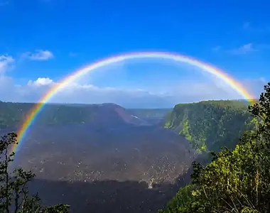
Trail access can change, so this page should not permanently claim that the trail is open. Before each departure, the guide checks the conditions affecting the Kīlauea Iki Trail, including:
-
Current trail access
-
Park closures
-
Weather
-
Rain and wind
-
Air quality
-
Volcanic gases
-
Volcanic activity
-
Ground conditions
-
The group’s walking ability
Route flexibility allows the guide to choose the most suitable available experience while following current National Park Service and safety requirements.
Active lava cannot be guaranteed.
Guided by People Who Know Kīlauea’s Landscape
Volcanoes Hiking Guides’ team brings experience in interpretive guiding, volcanic features and native ecology.
Their knowledge allows questions to be answered in the context of what the group can see around them.
“Yvonne’s knowledge is unmatched. She explained not only the volcano, but the surrounding wildlife and plants.”
Jess · GetYourGuide ★★★★★
May 10, 2026 ·

GUEST PROOF
What Guests Say About Crossing Kīlauea Iki?
These reviews come from the verified listing for the 4.5-hour Guided Hike Adventure: Kīlauea Iki and Lava Tube.
Tripadvisor
Travelers’ Choice
GetYourGuide
Guest reviews
Guest reviews
Frequently Asked Questions

Ready for Your Next Adventure?
Cross the Floor of Kīlauea Iki With an Interpretive Guide
Join a public small group for a 4.5-hour Kīlauea Iki hike covering approximately 4.5 miles through native rainforest and across the crater’s solidified lava lake. Your guide explains the 1959 eruption and the features preserved across the crater floor.
Open to guests aged seven and older who meet the hiking requirements, the experience costs $157.07 per person, tax included. The final route remains subject to current trail access, park conditions and safety requirements.
Tell us about your group’s ages, walking ability and interests if you would like help choosing the right experience.