



Updated: 5 days ago
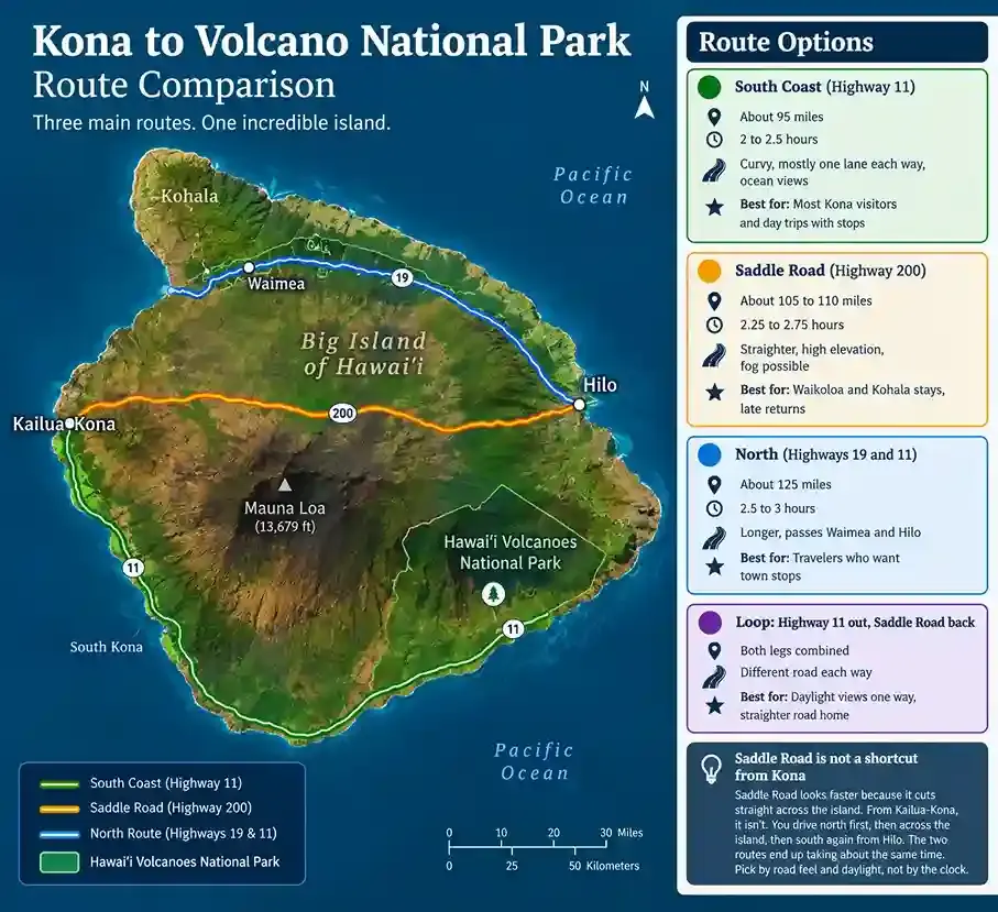
Kona to Hawaiʻi Volcanoes National Park is about 95 miles, a 2 to 2.5 hour drive on Highway 11. The northern route through Waimea and Hilo runs about 125 miles and takes 2.5 to 3 hours. Saddle Road sits in between, but from Kailua-Kona it saves no time.
You have one day, a rental car in Kailua-Kona and three roads on the map. One curves along the south coast. One crosses the island on a high-elevation highway. One loops north through Waimea and Hilo. Every site gives a different mileage. Few tell you what time you actually need to leave.
We guide hikes in Hawaiʻi Volcanoes National Park and on Mauna Loa, and many of our guests start their morning in Kona. [ASK JENNIFER: Add one real example of a Kona guest and what they learned about this drive.] So this guide does the planning math for you: the route, the leave time, the stops and what to expect when you arrive.
How far is Volcano National Park from Kona, and how long is the drive?
Kailua-Kona is about 95 miles from the park on Highway 11, a 2 to 2.5 hour drive. Hilo is about 30 miles away. Waikoloa is about 90 miles away via Highway 200.
Starting point | Route | Distance | Drive time |
Kailua-Kona | Highway 11 south | About 95 miles | 2 to 2.5 hours |
Kailua-Kona | Highways 19 and 11 via Waimea and Hilo | About 125 miles | 2.5 to 3 hours |
Waikoloa | Highway 200 (Saddle Road) | About 90 miles | About 2 hours |
Hilo | Highway 11 | About 30 miles | About 45 minutes |
These times get you to the park area, not to a specific trailhead or tour meeting point. Kona International Airport sits north of town, so starting there adds a few miles.
Why do websites give different mileage for this drive?
Search this drive and you'll see anything from 94 to 127 miles. The gap comes from where each site starts and stops measuring. Some begin at the airport, some in town, some at a resort. Some end at the park gate, others in Volcano Village. The drive time barely moves, though. Plan on about 95 miles and 2 to 2.5 hours, then run your exact start through Google Maps.
Set your GPS to the Kīlauea Visitor Center, not "Volcano, HI"
Volcano is both a search term and a place. Volcano Village is a small community just outside the park, with lodging and restaurants. A search for "Volcano, HI" can drop your pin in the village. For a self-guided visit, set your destination to the Kīlauea Visitor Center, just past the entrance.
Booked a hike with us? Use the map pin in your confirmation instead. Our meeting points differ by tour, and our meeting locations and directions page lists each one.
Add buffers to every estimate
Google Maps shows driving time. It doesn't show the entrance line, the parking search or a fuel stop. Add 20 to 30 minutes at the park end. Popular lots can fill by 10 am, so the later you arrive, the more that buffer matters.
Which route is best from Kona to Volcano National Park?
For most visitors starting in Kailua-Kona, Highway 11 along the south coast is the simplest and shortest route. Saddle Road suits people starting in Waikoloa or Kohala, or anyone who wants a straighter road home. The northern route earns its extra time only if you want to stop in Waimea or Hilo.
Route | Distance and time | Road feel | Best for |
South coast, Highway 11 | About 95 miles, 2 to 2.5 hours | Curvy, mostly one lane each way, ocean views | Most Kona visitors and day trips with stops |
Saddle Road, Highway 200 | About 105 to 110 miles, 2.25 to 2.75 hours | Straighter, high elevation, fog possible | Waikoloa and Kohala stays, late returns |
North, Highways 19 and 11 | About 125 miles, 2.5 to 3 hours | Longer, passes Waimea and Hilo | Travelers who want town stops |
Loop: Highway 11 out, Saddle Road back | Both legs combined | Different road each way | Daylight views one way, straighter road home |
Saddle Road is not a shortcut from Kona
Saddle Road looks faster because it cuts straight across the island. From Kailua-Kona, it isn't. You drive north first, then across the island, then south again from Hilo. The two routes end up taking about the same time. Pick by road feel and daylight, not by the clock.
What is the southern route (Highway 11) like?
The southern route follows Highway 11 along the Kona and Kaʻū coasts. It's mostly one lane each way, with curves, ocean views and few services south of Captain Cook. You pass the coffee towns and Punaluʻu Black Sand Beach. Mauna Loa's long slope rises beside you most of the way.
How does the drive feel?
It has more curves than Saddle Road, and speed limits run lower. It gets very dark at night and trickier in rain. No stretch runs along a cliff edge. In daylight, though, you see a lot of open ocean, and some drivers find that unsettling. [ASK JENNIFER: Add your own description of this drive, including one stretch where you tell guests to slow down.]
Fuel, food and restrooms
Fill your tank in Kailua-Kona. Fuel gets scarce south of Captain Cook, and there's no gas inside the park. Pack water and snacks too, because services thin out fast once you pass the coffee towns. Our trail food guide has easy ideas for the day.
Stops worth the time, and what each one costs
Every stop costs more than its visit time, because you also pay for the detour in and out. These are our planning allowances.
Stop | What it is | Plan on | Good to know |
Kona coffee farm | Farm tours and tastings in the Kona Coffee Belt on the Hualālai and Mauna Loa slopes | 45 to 60 minutes | Hours vary by farm. Check before you go |
Puʻuhonua o Hōnaunau National Historical Park and Two Step | A historic place of refuge and a popular snorkel entry | 1.5 to 2.5 hours | Parking at the bay is limited. The Tri-Park pass covers park entry |
Ka Lae (South Point) | The southernmost point of the 50 states | About 1 hour | Currents are strong and there are no lifeguards |
Papakōlea Green Sand Beach | A beach colored by olivine | 3 hours or more with the walk | Access rules vary. Read the note below |
Punaluʻu Bake Shop and black sand beach | A bakery, black sand and resting sea turtles | 45 to 60 minutes | Give turtles space |
Kahuku Unit of the park | A quiet section of Hawaiʻi Volcanoes National Park near mile marker 70.5 | 30 to 60 minutes | Open Thursday to Sunday, 8 am to 4 pm. No drinking water |
Now do the arithmetic. Leave Kona at 7:00 am and drive 2.5 hours, and you reach the park around 9:30. Add an hour at Punaluʻu and an hour at Kahuku, and you arrive near 11:30. By then, lots may be full and the clouds have often rolled in.
So flip the order. Drive straight to the park, then make your stops on the way home. Check Kahuku's 4 pm closing before you count on it.
Papakōlea and South Point: Read this first
The cliffs at Ka Lae look inviting, but strong currents and no lifeguards make jumping a real risk. We don't recommend it. Papakōlea needs a long walk or a ride on a rough access road. Don't plan around a paid shuttle until you confirm current rules with an official Hawaiʻi source. [VERIFY: Papakōlea access and shuttle rules.]
Give sea turtles room and leave the land as you found it
Honu, Hawaiian green sea turtles, rest on Punaluʻu's black sand. They're protected. Keep your distance, and never touch or feed them. The same care applies everywhere on this drive. Our leave no trace guide explains how we protect the land we hike.

Is Saddle Road (Highway 200) a good way to drive to the park?
Yes, if you start in Waikoloa or Kohala, or want a straighter road. From Waikoloa, it runs about 90 miles and takes about 2 hours. From Kailua-Kona, it saves no time.
What Saddle Road is?
Highway 200 is the Daniel K. Inouye Highway. It crosses the island for more than 50 miles between Hilo and Waimea. At its crest, it climbs to about 6,632 feet. It also leads to the Mauna Kea and Mauna Loa access roads.
The road has an old reputation. It once had one-lane bridges and rough pavement. Today it's well paved, mostly one lane each way, with a passing lane on some uphill stretches.
Fog, low clouds, goats and military traffic
Weather can sit on the crest while both coasts stay clear. Low clouds can cut visibility to a few car lengths. Goats wander near the road, and military vehicles use it near the Pōhakuloa Training Area. Turn on your headlights, slow down in cloud and watch the shoulders.
Gas, food and restrooms
There are no services along Saddle Road. Fill up in Kona, Waimea or Hilo first. Gilbert Kahele Recreation Area, a few miles before the Mauna Kea turn, has restrooms. [VERIFY: Gas station locations and hours in Kona and Waimea, and Gilbert Kahele restrooms.]
Check your rental car contract
Many rental companies used to ban Saddle Road, and most now allow it. Terms vary by company and vehicle, so read yours before you go. The paved road to the Mauna Kea Visitor Information Station is open to most cars. The gravel road past it is off limits to most rentals.

Should you take the northern route through Waimea and Hilo?
Take the northern route only if you want to stop in Waimea or Hilo. It runs about 125 miles and 2.5 to 3 hours via Highways 19 and 11. That's about 30 minutes longer than the south route, and more once you add town stops.
What do you gain?
Services: Waimea, a green upcountry ranching town near 2,700 feet, and Hilo both have gas, food and shops.
Waterfalls: Rainbow Falls sits right in Hilo. ʻAkaka Falls State Park is a short detour off Highway 19. Check its entry fees before you go.
Supplies: Hilo is the last big town before the park, so stock up on water, snacks and layers there.
What does it cost?
You spend extra time and extra miles. The full loop, one coast each way, runs about 220 miles and 5 to 6 hours of driving. Many travelers take this route one direction and Highway 11 the other. That gives you both coasts without doubling the long leg.

Which route is safest, especially after dark?
No route from Kona runs along cliff edges. The bigger risks are darkness, fog, fatigue and other drivers. No road is risk-free, and no one can promise conditions on any given day.
Day versus night
Condition | South coast, Highway 11 | Saddle Road, Highway 200 |
Daylight | Ocean views and curves | Open road, fog possible |
After dark | Very dark and curvy, with oncoming traffic | Fewer curves and less traffic, but low cloud, goats and no streetlights |
Rain | Trickier on curves | Cloud and fog more likely higher up |
Services | Thin south of Captain Cook | None along the road |
Our take
[ASK JENNIFER: Which route do you tell guests to take in daylight, and which after dark? Give one or two sentences in your own words and the reason.]
The two-road plan
Many visitors drive the south route by day and Saddle Road home at night. That works well for sightseeing. But weigh your energy, too. The round trip is about 190 miles, before you count your hours in the park. If you'll be tired, a night near the park removes the night drive entirely.
The real risk
The biggest risk is usually other drivers, and yourself. Take breaks, share the driving and don't rush. Always follow the posted limit, even on Saddle Road's long straight stretches.
Can you visit the park as a day trip from Kona?
Yes, a Kona to Volcano National Park day trip works, but it's a long day. The round trip is about 190 miles, with 4 to 5 hours behind the wheel before any stops. Door to door, most full days run 10 to 12 hours.
Sample timelines
Plan | Leave Kona | Reach the park | Time in the park | Back in Kona |
Guided 8 am hike, then home | About 4:45 to 5:15 am | About 7:15 am | A 3-hour hike, then lunch and a short visit | About 2:30 pm |
Self-drive, one stop on the way home | About 7:00 am | About 9:30 am | About 4 hours, then a 1-hour stop | About 5:00 pm |
Late start | About 10:00 am | About 12:30 pm | Shorter, and lots may be full | Varies |
These are planning estimates. Traffic, entrance lines and stops will change them.
Why does morning win?
Mornings usually bring the clearest crater views, because the weather often changes later in the day. You also get open parking and cooler trails. Our lead guide plans every first hike of the day around that window.
The fatigue math
Count the full day. Four to five hours of driving, plus a 3-hour hike, plus lunch, plus a short visit. That adds up to 8 to 9 hours. Plan more rest than you think you need.
Pick one part of the park
Don't try to see everything on a day trip. The summit area and Chain of Craters Road are separate trips. Choose one for a half day.
When to stay overnight instead?
Staying near the park saves the return drive. Volcano Village has lodging just outside the gate, and Hilo is the larger option 30 miles away. Arriving the evening before puts you at the park early, before the lots and clouds fill in.
What time should you leave Kona for a guided hike?
Plan to reach your meeting point 15 minutes before the start time. The 2 to 2.5 hour drive gets you to the park area. Add time for the entrance and parking. Meeting points differ by tour.
Tour | Start | Meets at | Leave Kona |
Fri to Sun, 9 and 11 am | U.S. flagpole at Kīlauea Military Camp | 5:45 to 6:15 am for 9 am. 7:45 to 8:15 am for 11 am | |
Daily, 8 am, 12 pm and 3 pm | Kīlauea Military Camp | 4:45 to 5:15 am for 8 am. 8:45 to 9:15 am for 12 pm. 11:45 am to 12:15 pm for 3 pm | |
Daily, 8 or 10 am | Kīlauea Iki Overlook | 4:45 to 5:15 am for 8 am. 6:45 to 7:15 am for 10 am | |
Daily, 8 to 10 am | Kīlauea Visitor Center area, or the pin in your confirmation | 4:45 to 7:15 am, depending on start | |
Daily, 8 to 10 am | Puʻu ʻŌʻō Trail area, off Saddle Road | [ASK JENNIFER: Kona drive time to the trail area] |
These times assume a 2 to 2.5 hour drive and a 15-minute early arrival. They also include a 30-minute buffer for the entrance and parking. Always follow your confirmation message.
What happens if you run late?
A public group may wait up to 15 minutes after the start time. A private hike may wait up to 45 minutes. Once the group leaves, a late guest can't join, and we don't extend the finish time. If you're running behind, call your guide.
Which park hike fits a day from Kona?
Choose by effort. The steam vent walk and the Keiki to Kūpuna tour are the easier options. The Kīlauea Iki hike and the 6-hour tour ask for more fitness. See all our group volcano hikes. Want a start time that fits your drive? A private Kīlauea Iki hike can start anywhere from 8 to 10 am.
The Mauna Loa hike from Kona
Our Mauna Loa hike is outside the national park, in the Puʻu ʻŌʻō Trail and Saddle Road area. It doesn't use the main park entrance, so don't buy a park pass unless your confirmation says so.
The trail sits near 6,500 feet in wet forest, so cool air, rain, wind and fog are all possible. You get a map pin and written directions, usually the day before. Save them offline before you leave your hotel. There are no restrooms at the start. Bring at least 1.5 liters of water per person.

Does the time of year change your drive from Kona?
The park is open year-round, and the weather depends more on elevation and wind than on the month. April to October is often called the dry season. Still, the summit can be wet, foggy or windy in any month.
The Kona coast sits near sea level, where highs often reach the 80s°F. The Kīlauea summit sits around 4,000 feet and runs 12 to 15°F cooler, and it's usually wetter. Pack layers, a rain shell, sturdy closed-toe shoes, water and sun protection. Our packing list for volcano hikes covers the rest.
Winter at the summit is often cooler and wetter. Trade winds tend to be steadier from May through September, which can mean clearer air. Spring is changeable. Parking fills earliest in December, January, June and July.
A Kailua-Kona forecast won't tell you what the summit will do. Our guide to the best time to visit breaks down each season.
What should you check before you drive?
Check park conditions and the volcano's status the morning you leave. This park changes faster than most travel guides get updated.
Where to check, in order:
Park conditions: The park's conditions page and the NPS App list closures, construction and air quality alerts.
Volcano status: The USGS Hawaiian Volcano Observatory shows whether Kīlauea or Mauna Loa is active.
Traffic: Check Google Maps before you leave Kona.
Bus times: Check the Hele On site, if you're riding.
Trail closures and summit construction
A multi-year repair project at the summit can close buildings and slow traffic. Trails can also close for weeks after a run of earthquakes, as Halemaʻumaʻu Trail did in October 2026. Have a backup plan for any single trail.
The Hōlei Sea Arch is gone
Many older guides still send visitors to the Hōlei Sea Arch at the end of Chain of Craters Road. The 90-foot arch fell into the sea on September 27, 2026. The road is still a scenic drive to the coast. Stay behind every barrier, because the coastal cliffs are unstable.

Volcanic gas and air quality
Volcanic gas can affect people with asthma, heart or lung conditions, young children and pregnant women. Check air quality often during your visit, not just once. Our volcano hiking safety guide explains vog in more detail.
What does park entry cost, and where do you park?
A private vehicle pass costs $30, covers everyone in the car and lasts seven days. The park is cashless, so bring a card.
Option | Price | Notes |
Private vehicle | $30 | Driver plus up to 14 passengers. Valid 7 days |
Motorcycle | $25 | Up to 2 motorcycles. Valid 7 days |
Individual on foot or bike | $15 | Age 16 and up. Valid 7 days |
Hawaiʻi Tri-Park Annual Pass | $55 | Covers this park, Haleakalā and Puʻuhonua o Hōnaunau. US residents only |
America the Beautiful annual pass | $80 US residents, $250 non-residents | Covers most federal parks and sites |
Fees can change, so confirm them on the park's fees page before you go.
What changes on a guided hike?
Park entry isn't included in our tour price. For commercial guided tours, the fee is $15 per person aged 16 and older. Guests 15 and younger are free. Our park entry and meeting page explains which fee applies to your booking. The Mauna Loa hike meets outside the park, so it skips the entrance station.
Parking tips
Arrive early: Popular lots fill by mid-morning, especially on eruption days.
Kīlauea Iki Overlook: Parking is limited and fills quickly.
Nāhuku (Thurston Lava Tube): Parking is extremely limited. Come before 9 am or after 5 pm.
If a lot is full: Don't park on the shoulder. Move on to the next stop, or call your guide if you're on a tour.
Can you get from Kona to the park without a car?
Not easily. Most visitors rent a car. There's no shuttle inside the park, and rideshare apps rarely work out here.
Self-drive or guided tour: Which fits your day?
Self-drive | Pickup tour from another operator | Guided hike with us | |
Who drives | You | The operator | You |
Pace | Yours | Set by the operator | Set by your guide, small group |
Park entry | Vehicle pass | Ask the operator | Not included in our price |
Best for | Flexible days | Visitors who don't want to drive | Hikers who want a guide on the trail |
Our group tours have a maximum of 10 guests, and we don't offer hotel pickup. Not sure a guide is worth it? Read why explore the park with a guide.
Hele On bus
The Hele On bus serves the park seven days a week. It stops at the Volcano House intersection and at the second entrance to the Kīlauea Visitor Center. From Kona, the trip needs transfers and takes over three and a half hours each way. Riders pay the park entry fee to the driver. [VERIFY: Current Kona-to-park bus routes, times and fee collection on the Hele On website.]
For a guided hike, the bus isn't a good fit. Our hikes move between locations, and there's no shuttle between them.
Rideshare
The park is about 30 miles from the nearest town with rideshare drivers. Getting a ride out can be very hard, and sometimes impossible. Don't count on one to get home.
Rental cars
Reserve a car at Kona or Hilo airport, and book early in busy months. You can't rent a car or bicycle inside the park.
Pickup tours from Kona
Several companies run pickup tours from Kona, including full-day trips. We don't. We offer no hotel pickup or shuttles, so our guests drive their own or a rental vehicle. If you'd rather not drive, book a pickup tour with another operator.
What should you do once you arrive?
Start at the Welcome Center, then pick one area: the summit or Chain of Craters Road. This is a short starter plan. Our guide to 20 things to do in Hawaiʻi Volcanoes National Park covers every stop in detail.
Why is the park worth the drive?
Hawaiʻi Volcanoes National Park protects two of the world's most active volcanoes, Kīlauea and Mauna Loa. It became a national park on August 1, 1916, and a UNESCO World Heritage Site in 1987. It covers about 354,461 acres. It's also one of only two national parks in Hawaiʻi. The other is Haleakalā on Maui. In one day, you can see steam vents, old lava flows, native rainforest and sea cliffs.
Start with a ranger and the conditions
The Welcome Center sits at Kīlauea Military Camp, 1.2 miles past the entrance. It's the visitor desk while the Kīlauea Visitor Center is renovated. Rangers post the day's conditions, trail access and ranger programs. They can also give safety advice for your plans.
Crater Rim Drive and the summit area
Crater Rim Drive runs along the caldera's edge in two directions from the entrance. Stops include steam vents, overlooks and the Devastation Trail. That trail is a paved 1-mile round trip, about an hour, through forest buried by cinder in 1959. It's wheelchair and stroller accessible, though some grades run steeper than 8%.
Nāhuku (Thurston Lava Tube)
Nāhuku is a 500-year-old lava tube you can walk through, wrapped in dense rainforest. It's a 1.5-mile round trip from Kīlauea Iki Overlook. The tube is lit from 8 am to 8 pm. Watch for low ceilings, standing water and tripping hazards.

Chain of Craters Road
Chain of Craters Road runs about 18.7 miles from the summit to the coast. It takes about 30 minutes one way without stops. You pass lava fields and overlooks on the way down. Stop at the Puʻuloa Petroglyphs, where ancient Hawaiian carvings cover the rock. Stay on the boardwalk and never touch the carvings. There's no food, water or fuel on this road, so stock up first.
Hikes by effort
Hike | Distance | Time | Difficulty |
Devastation Trail | 1 mile round trip | About 1 hour | Easy, paved |
Kīlauea Iki Trail | 3.3-mile loop from the overlook | 2 to 3 hours | Moderate to challenging, about 400 feet down and back up |
2.5 miles round trip | 2 to 3 hours | Moderate, with one steep quarter-mile climb | |
Mauna Loa summit | Multi-day trek to 13,681 feet | 2 nights or more | Strenuous, backcountry permit required |
What mistakes do visitors make on this drive?
These are the mistakes that cost the most time.
Typing "Volcano, HI" into the GPS: You may land in the village. Use the Kīlauea Visitor Center or your booking pin.
Arriving late: Lots fill and clouds roll in. Leave earlier than feels necessary.
Skipping fuel in Kona: Fuel is scarce south of Captain Cook, on Saddle Road and inside the park.
Packing for Kona weather: The summit is cooler and wetter. Bring layers.
Stacking stops on the way in: Two stops can push your arrival past 11:30. Save them for the drive home.
Driving home tired in the dark: Consider a night near the park instead.
[ASK JENNIFER: Which of these do you see most often? Add one real example, with details you're comfortable sharing.]
Frequently asked questions about driving from Kona to the park
Do you need a 4WD to drive from Kona to the park?
No. Highway 11, Saddle Road and the northern route are all paved, and any regular car can drive them. You only need a 4WD for rough side roads, like the road past the Mauna Kea Visitor Information Station. Most rental contracts ban those roads anyway, so read yours before you go.
Do you need a reservation to visit Hawaiʻi Volcanoes National Park?
No. Day visitors don't need a reservation or timed-entry ticket. You just buy an entrance pass at the gate or online. You do need to book ahead for campsites, backcountry permits and guided hikes. On busy days, arriving early matters more than any booking.
Is it better to stay in Kona or Hilo to visit the park?
Hilo is much closer, about 45 minutes from the entrance. Kona is 2 to 2.5 hours away but has more resorts, sunshine and beaches. If the park is the main reason for your trip, stay a night or two in Hilo or Volcano Village. If it's one day of many, Kona works with an early start.
Can you see lava on a day trip from Kona?
Only if Kīlauea is in an eruption episode that day. Since late 2024, it has erupted in episodes lasting hours, with pauses of days or weeks. The glow looks best after dark, which means a long drive home at night. See what Episode 50 looked like from the rim. We never promise lava.
Is Hawaiʻi Volcanoes National Park open at night?
Yes. The park is open 24 hours a day, every day. Roads are dark and services are limited after hours, and we don't run night hikes. Staying for the glow or the stars? Plan your drive back first, or book a night in Volcano Village.
Can you hike Mauna Loa on a trip from Kona?
Yes, but pick the right hike. The summit trail climbs to 13,681 feet, takes several days and needs a backcountry permit. Altitude sickness, whiteouts and freezing nights are real risks. For a day hike, try our private Mauna Loa Ancient Forest and Bird Hike. It follows the Puʻu ʻŌʻō Trail at about 6,500 feet for about 5 hours.
Have a question about our hikes? Our FAQ page covers meeting points, what's included and how to book.
Your drive from Kona to Volcano National Park, planned
Back to the start. You have one day, a rental car and three roads. Now you know the numbers. About 95 miles and 2 to 2.5 hours on Highway 11. Saddle Road is straighter but no faster. The loop through Waimea and Hilo is the long way round.
Here's your next step, in order:
Pick your route: Highway 11 for stops and views, Saddle Road for a straighter drive home.
Set your leave time: Use the tables above, and add a buffer for the entrance and parking.
Check conditions: Look at park alerts and the USGS update the morning you drive.
Want a guide on the trail? Browse our group volcano hikes, or book a private volcano tour at a time that fits your drive. Questions? Send us a message.
Which route are you leaning toward, and what time are you leaving Kona?
About the author
Jennifer Bell is the founder and lead guide of Volcanoes Hiking Guides. She holds a BA in Recreation Management from the University of Montana. Before Hawaiʻi, she worked as a guide in Yellowstone and in environmental education. Jennifer is a certified Wilderness First Responder. She is also listed as an owner and guide on the company's Commercial Use Authorization. Together, our guides bring more than 20 years of combined professional guiding experience.


Comments